I didn’t think there was much more that could be done with the database of Farm Security Administration/Office of War Information photographs in the Library of Congress. Then I was made aware of the Photogrammar project from Yale University.
The project is a new way of looking at the work in the FSA/OWI archive. The Library of Congress has had a searchable database of these images, along with many digitized versions of the photographs. Searching for a photographer or a topic or even a location would return a list of photographs matching those terms. So I didn’t think the Photogrammar project was going to be much more than a different way of accessing the same database.
In some respects, that’s true. The main apparent difference is that instead of a search box, visitors to the Photogrammar site are presented with a map of the US. Different shades of green indicate the frequency with which a location is represented in the photographs of the FSA/OWI archive.
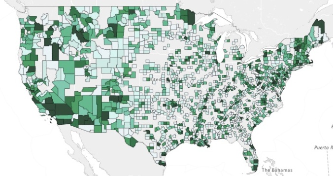
There are a couple of neat things about this. First, the visual presentation means that if I can’t think of the name of a specific location or don’t have the right spelling, I can still find it on the map. I can also easily see nearby areas where photographers might have worked. Second, it’s an immediate look at the breadth of where the FSA/OWI photographers worked during the project. There heavily-covered areas are immediately apparent, as are the ones that got little attention. I like this map for what it says about the sociology of the project.
There’s another aspect of this project that definitely adds to the information available. According to one of the blog posts on the project site the call numbers associated with the individual photographs in the Library of Congress archive had a letter/number combination at the end. A little digging indicated that the numbers presented a sequence, as in the order of frames on a strip of negatives. This led the researchers to investigate further, eventually determining that using the codes could allow them to reconstruct the order in which the photographs were made. So now instead of seeing a list of photographs that a photographer made in a specific location we have the opportunity to investigate the order in which the photographs were made and what that tells us about the photographer’s approach.
That’s kind of cool, and it adds to the potential for teaching and research of the LOC archive of these images. Thanks to the people at Yale for taking on this project. Check it out by clicking on the link or the map above.
